Everglades National Park is the largest designated wilderness area east of the Mississippi, a World Heritage Site, an International Biosphere Reserve, and a Wetland of International Importance. Everglades National Park is also one of the most accessible national parks there is. It’s surrounded by nearly three million people that live in surrounding
Miami-Dade and Collier counties. Historically the Everglades tied all of south Florida together in a seasonal cycle of wet and dry. To meet the demands of Florida’s population growth, the historic Everglades have been drained, diked, dammed, and disconnected from the seasons, leaving it diminished but alive.
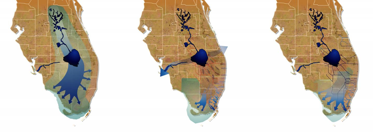
The Greater Everglades ecosystem historically encompassed 2.6 million acres from central Florida, near Orlando, all the way down to the Florida Keys. Water flowed south into Lake Okeechobee which, during the rainy season, filled up and spilled over its banks. The flood water then made its way across a variety of habitat types – including sawgrass
plains, open-water sloughs, rocky glades, and marl prairies – and finally into the Gulf of Mexico and Florida and Biscayne Bays. This vast Everglades ecosystem contains a unique array of wildlife and habitats found nowhere else on earth.
South Florida averages about 50 - 60 inches of rain annually. Florida, the Everglades in particular appears incredibly flat. When standing in the midst of the river of grass any slope is hardly discernible, yet there is one. Lake Okeechobee sits about 24 feet above sea level causing water to flow south dropping about 4 inches per mile only moving about
100 feet per day.
Water descends through slight depressions creating a river called a slough (pronounced ‘slew’) channeling freshwater south to Florida Bay. On the eastern side of the park Taylor slough passes through the Royal Palm area, which is home to an incredible array of botanical diversity featuring orchids, bromeliads, ferns, and more. In the center of the park
the Shark River slough passes through Shark Valley and vast swaths of marshy wetlands. A series of other sloughs that flow through the Big Cypress Swamp supply freshwater to western Florida Bay and the Ten Thousand Islands, a vast mangrove forest.
The grasses, for which the Everglades is most associated with are located in the freshwater sloughs that bisect the park. These sloughs feature sawgrass that can grow up to six feet or more, along with broad-leafed marsh plants. Freshwater sloughs are excellent locations for bird rookeries and attract a great variety of wading birds such as herons,
egrets, roseate spoonbills, ibis, pelicans, and more. Countless other birds make this a stop over during long migratory routes. Over 360 different bird species has been identified within Everglades National Park. During an expedition in 1832 John James Audubon described, "We observed great flocks of wading birds flying overhead.... They appeared in such numbers to actually
block out the light from the sun for some time." Sloughs also feature a great abundance of fish, amphibians, turtles, alligators, and snakes. Further downstream where the freshwater sloughs meets the saltwater you can find crocodiles.
The Ten Thousand Islands are a chain of islands and mangrove islets along the southern coast of Florida. Mangrove habitat serve as a valuable nursery for shrimp, crabs, and a variety of other important endangered and commercial marine species. During the dry winter months, wading birds congregate here to feed and nest. During the wet summer months,
these mangroves forests provide the first line of defense against the howling winds and storm surge of hurricanes. Mangroves thrive in tidal waters such as these where freshwater from the Everglades mixes with the saltwater of the bay. Everglades National Park contains the largest contiguous stand of mangrove forest in the western hemisphere.
The story of life centers around water. Most cities are built on or near a water source. Water is the lifeblood of the Everglades. However, the development of south Florida has centered on draining and controlling the flow of water. The pre-drainage system boasted over 2.5 million acres of wetlands, highly diverse biomass, even continuous sheetflow of
water, and water storage between wet and dry cycles.
Beginning in 1890 diversion projects began redirecting water and draining the swamp for agricultural, business, and residential development. As a result the Everglades ecosystem has been reduced by 1.25 million acres. Six major Everglades habitats are now only remnants of their former selves. Others are highly fragmented. Biodiversity has declined
significantly. Everglades National Park supports 90% fewer nesting birds than it did prior to drainage and is home to 68 threatened or endangered species. Sheetflow and water storage has dramatically declined, disrupting natural cycles.
Historically, over 450 billion gallons of water per year flowed southward into Everglades National Park across US 41, the Tamiami Trail. Today, only 260 billion gallons of water flow along this path. The road, in conjunction with levees and canals acts as a giant dam obstructing the natural sheet flow. In 1999, the U.S. Army Corps of Engineers
submitted a proposal to Congress to restore south Florida’s natural ecosystem, while maintaining urban and agricultural water supply and flood control. Congress approved the Comprehensive Everglades Restoration Plan (CERP). The CERP approach is to use the best available science to restore the "right quantity, quality, timing, and distribution" of freshwater to the natural
system.
There are four components to the CERP restoration plan, one of which aims to restore natural sheetflow. Levees are being taken down, canals are being filled in, and two elevated bridges are being constructed to allow natural sheetflow to return to the environment. The entire plan should be complete by 2030 and aims to restore up to 75% of the flow the
park received before construction of the canals and the Tamiami Trail.
Everglades National Park is both unique and endangered. It stretches in the north from Orlando south towards the keys. Spanning from Naples and the Gulf of Mexico to Miami and the Atlantic. It’s an ecosystem of local, national, and global importance, defined and connected by water. Historically the Everglades tied all of south Florida together in a
seasonal cycle of wet and dry. To meet the demands of Florida’s population growth, the historic Everglades have been drained, diked, dammed, and disconnected from the seasons, leaving it diminished but alive. With the implementation and completion of the Comprehensive Everglades Restoration Project it has a fighting chance to flourish once again.