| The Chesapeake & Ohio Canal 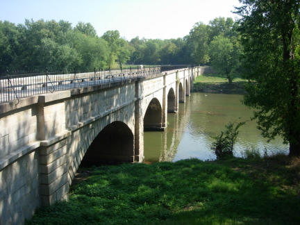 The Byway begins at a striking geologic formation named Point of Rocks, at which Catoctin Mountain is split by a gap caused by the Potomac River. Here, on the Point of Rocks Bridge, automobile transportation spans a legendary railroad line (B&O) and a canal system proposed by George Washington to transport goods from the west. The Chesapeake and Ohio Canal National Historical Park and Trail can be found up and down the western bank of the Potomac. The Byway begins at a striking geologic formation named Point of Rocks, at which Catoctin Mountain is split by a gap caused by the Potomac River. Here, on the Point of Rocks Bridge, automobile transportation spans a legendary railroad line (B&O) and a canal system proposed by George Washington to transport goods from the west. The Chesapeake and Ohio Canal National Historical Park and Trail can be found up and down the western bank of the Potomac.
Originally, the C&O Canal was a lifeline for communities and businesses along the Potomac River as coal, lumber, grain and other agricultural products floated down the canal to market. Those who planned and designed the canal saw it stretching from the Potomac River near Washington D.C., to the Ohio Valley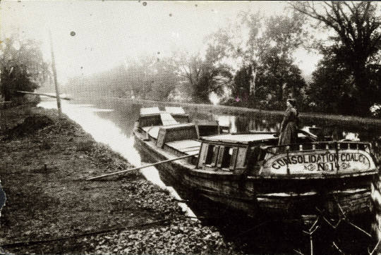 . Work commenced on July 4th, 1828, but the challenges and costs experienced were far greater than estimated. By 1850, the canal was complete from the mouth of Rock Creek in Georgetown to Cumberland in western Maryland. The canal never made it further west, with the Ohio River as its goal. Despite problems such as frequent flooding, the canal was a busy waterway for the transport of coal and produce. In 1924, a major flood all but destroyed the canal, leading to its closure in 1924. In 1971, the federal government made the old canal right of way from Georgetown to Cumberland a national historic park. . Work commenced on July 4th, 1828, but the challenges and costs experienced were far greater than estimated. By 1850, the canal was complete from the mouth of Rock Creek in Georgetown to Cumberland in western Maryland. The canal never made it further west, with the Ohio River as its goal. Despite problems such as frequent flooding, the canal was a busy waterway for the transport of coal and produce. In 1924, a major flood all but destroyed the canal, leading to its closure in 1924. In 1971, the federal government made the old canal right of way from Georgetown to Cumberland a national historic park. 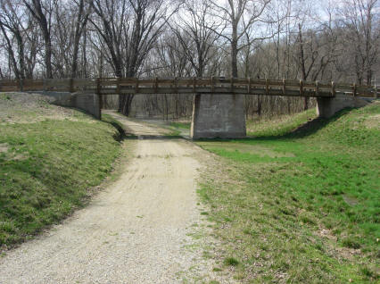 Today millions of visitors hike and bike the C&O Canal each year to enjoy the natural, cultural and recreational opportunities available. Point of Rocks is located at mile marker 48 of the canal's 184.5 route north west from Georgetown and features a reconstructed pivot bridge. To the west (via MD464 and Lander Road), you'll find Lander the site of a lock house and the Catoctin Aqueduct, one of 11 such stone structures along the canal. Aqueducts were built in the early 1800’s by the Chesapeake and Ohio Canal Company to carry the canal over major tributaries of the Potomac River. This crossing over Catoctin Creek was nicknamed the “crooked aqueduct” due to the sharp curves in the canal at each end of the structure. The aqueduct is a three arch structure with a center elliptical arch. The structure fell into a progressive deteriorated state upon closure of the canal operations in 1924. It had a major failure in 1973 when the weakened structure partially collapsed into Catoctin Creek. A local grassroots effort is underway to restore the Catoctin Aqueduct to its original condition. Today millions of visitors hike and bike the C&O Canal each year to enjoy the natural, cultural and recreational opportunities available. Point of Rocks is located at mile marker 48 of the canal's 184.5 route north west from Georgetown and features a reconstructed pivot bridge. To the west (via MD464 and Lander Road), you'll find Lander the site of a lock house and the Catoctin Aqueduct, one of 11 such stone structures along the canal. Aqueducts were built in the early 1800’s by the Chesapeake and Ohio Canal Company to carry the canal over major tributaries of the Potomac River. This crossing over Catoctin Creek was nicknamed the “crooked aqueduct” due to the sharp curves in the canal at each end of the structure. The aqueduct is a three arch structure with a center elliptical arch. The structure fell into a progressive deteriorated state upon closure of the canal operations in 1924. It had a major failure in 1973 when the weakened structure partially collapsed into Catoctin Creek. A local grassroots effort is underway to restore the Catoctin Aqueduct to its original condition.
Further west, Brunswick is home to the C&O Canal National Historic Park Visitor Center. Canal lock 30 and a portion of the towpath can be found here. Southeast of Point of Rocks (via MD 28 to MD 85) at the confluence of the Monocacy and Potomac Rivers is the aptly named Monocacy Aqueduct, the largest of the C&O's aqueducts. Described by historians as one of the finest canal structures in the nation, the Monocacy Aqueduct is constructed primarily of large granite blocks that came from nearby Sugarloaf Mountain. Learn more about the Chesapeake & Ohio Canal |